


Ancient Aptera
Ancient Aptera
The ancient city-state Aptera was founded in the 8th century BC and is situated in the Souda gulf, in a position of great importance. Today it is situated within the Souda municipality area in Chania .
Aptera used to be a very important city-state and has played a key role in the history and the politics of Crete. Aptera flourished in the Early Hellenistic period and was continuously inhabited until the Arab occupation in the 9th century, when it was destroyed and abandoned.
Aptera was founded in the Geometric period and used to be one of the most powerful city-states in Crete . According to the legends, the city’s name, which in Greek means "without wings", derives from the Sirens, who lost their wings after being defeated by the Muses in a musical competition that took place in the area. Furthermore, “aptera” was also a nickname of Diana who had been worshiped in the area for centuries and is inscribed in coins.
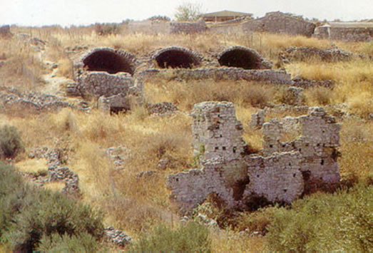
The remains of the city walls of Aptera are circa four kilometers long. They were built in the 3rd century BC and its formidable, large stone construction shows the wealth of the city in the Hellenistic period. Inside the walls, in the middle of the site, the remains of a small double sanctuary of the Classical era (late 5th – 4th century BC) lay in a protected area. Besides the city walls , other important ancient buildings are the vaulted Roman cisterns, the well-built double sanctuary of the 5th-4th century BC and the ruins of a small theater curved on rock. Findings from Aptera (vessels, coins, figurines, inscriptions, sculptures etc) are exhibited in the Archaeological Museum of Chania.
Near the eastern side of the walls, a Roman building with three arches which is believed to have been bouleuterion has been uncovered. Following the path behind the monastery of Agios Ioannis Theologos, you can visit two impressive, vaulted Roman cisterns. .
Many tombs of the ancient necropolis have been excavated outside the city walls, in the area of Plakalona, Megala Chorafia. In a short distance, near Stylos village, part of a Minoan settlement with a pottery kiln and a Late Minoan tomb were found on a hill. A Late Minoan settlement in Samona area, near Stylos village, is still excavated. .
Two fortresses of great historical interest built during the Turkish occupation are also situated in the broader area of the archaeological site. Palekastro fortress was built by the Turks because of the Cretan Revolt of 1866 and Izzeddin fortress was built in Kalami area in 1872. Izzeddin fortress housed barracks, hospital and other buildings.
Maps
Lodgings map
Accommodation in Crete:
- Chania
- Rethymno
- Heraklion
- Lasithi